Wednesday, July 13, 2016

Harriman Kakiat & Pine Meadow Lake Loop

Harriman State Park  - Kakiat and Pine Meadow Lake Loop

Hiked on July 4, 2016

Parking

Going through Suffern, NY via Route 59, take Route 202 North about 3.5 miles to the entrance for Kakiat Park on the left.

Trails

NYNJTC Map 118 (Harriman South)
From the parking area, through the gate, over the foot bridge, follow the woods road
West (straight) onto Orange Mountain Trail
West (left) onto White Kakiat Trail
North (right) onto Black Circle Racoon Brook Hill Trail
North (right) onto Yellow Circle Poached Egg Trail
Left on woods road
East (right) onto Red Pine Meadow Trail
East (right) onto White Conklins Crossing Trail
South (right) onto Yellow Suffern-Bear Mountain Trail
East (left) onto White Kakiat Trail
Left onto Blue Old Mill Tail
Finish at woods road back to parking lot

Description

When I set out on this hike I wasn't expecting too much. I have hiked much of southern Harriman and it is very nice but I was pleasantly surprised by several aspects of this look - a thigh busting climb, some pristine woodland, rock scrambles, and a beautiful loop around Pine Meadow Lake. It was a very enjoyable hike.

Park in Kakiat Park and head toward the bathroom hut to the path across the drive, near where cars enter the parking area. Continue on the wide path and cross the bridge. Keep going straight and you'll pass markers for the blue and white trails. Straight ahead and you'll see the Orange Mountain Trail marker. The Orange trail climbs up on Cobus Mountain with a couple of nice lookouts towards the east. They are a welcome stop to catch your breath. Past the power lines and the clearing for the gas pipeline, Orange ends into the White Kakiat Trail. Take a left (west) here. Be careful not to follow the woods road as I did.

Kakiat continues to climb and passes the Yellow Suffern-Bear Mountain (S-MB) trail. This is where we'll come back. Further on you're passing though forest where you can't even see the trail. You're just jumping from rock to rock and not hitting dirt. Without the blazes, there is no way to follow a trail. Truly a leave-no-trace area. Very nice. I found the trail a little hard to follow in places but didn't take more than a minute to find the next blaze.

Along Kakiat there were lots of blueberries and in early July there was lots to eat if the bush got some sun. Very nice. Kakiat edges the pipline and it was here that I got very close to a turkey. I was surprised it didn't run off, as they usually do as soon as they see you. I was wondering why and then I saw a little turkey chick dart in the bushes. That's why the mother was sticking around. Not wanting to be a nuisance, I just let them be and kept going.

At the intersection of the Black Circle on White Racoon Brook Hills Trail, take a right (north). Shortly you're climbing up a steep but short hill that takes some big steps and rock scrambling. There is even a wood ladder to help. A fun climb.

On the other side you'll begin to see the lake (or hear people if it's swimming weather). Look for the Yellow Circle Poached Egg trail which shortly leads to a woods road (Pine Meadow Road). Take a left at the road and follow it around the lake until you see the Red Pine Meadow Trail. There were lots of people sunning on the boulders and playing in the lake. At the Red trail there is a big No Swimming sign but I don't think it deterred anybody. Follow Red to the right continuing along the lake. There are many pockets here to get out to the lake edge and enjoy the view. I saw a couple of tents set up and thought it would be a great place to backpack when it isn't swim season.

Once Red heads away from the lake you'll see the White Conklin's Crossing trail heading east. Follow White to Yellow S-MB once again climbing Cobus Mountain (short for Jacobus?). Take a right and head south with a few ups and downs. In about 1 mile you'll intersect White Kakiat again. Go left (east) and start on the long way down. It gets a bit steep in spots and with the loose rocks you need to watch rolling. Once it levels out you are near the end. You can follow Kakiat back to the path to the parking area or take a left at the Blue Old Mill trail for a diversion. There are remnants of the sluice and mill on the creek.

My GPS tracker didn't work so I don't have an accurate mileage read, but I would estimate 5.5 miles. It took me about 4 hours with breaks.

Pictures

Blueberries are ripening
Ladder on Raccoon Brook Hill Trail

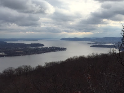
View of Pine Meadow Lake

Fern Glade

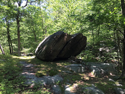
Interesting split boulder (erratic maybe?)


Thursday, June 16, 2016

Schunemunk Mountain Loop

Schunemunk Mountain Loop

Hiked on May 14, 2016

This hike goes up Schunemunk Mountain in Mountainville, NY. Schunemunk is a double ridged mountain with Baby Brook flowing between the ridges.

Parking

From Ringwood I took 17N to 32N to Creamery Hill Rd, Starr Rd, and Taylor Drive. There is a parking area on Taylor Drive (just past Creekside Ln) for about 10 cars.

Trails

NYNJTC Trail Map 114
From the parking area, cross the street and follow Yellow Jessup Trail
North (right) onto White Sweet Clover Trail
West (left) onto Orange Western Ridge Trail
South onto Blue Ridge-to-Ridge Trail
East (left) onto Yellow Jessup Trail
Side trip on White
South onto Black Dark Hollow Trail
About 100 yds West by the train tracks
South (right) onto White Sweet Clover Trail
South (right) onto Yellow Jessup Trail

Description

Followed the Yellow Jessup Trail across a field into the woods. The trail follows Baby Brook up the mountain. This is a good ascent with a nice waterfall. Continued Jessup onto the Eastern Ridge with great views of the Hudson, Newburgh, and the Newburgh-Beacon Bridge.

The rock on the ridge is conglomerate with lots of quartz stones of varying size up to about 4 or 5 inches. If you're interested, check out the puddingstone page on Wikipedia. It talks about the Schunemunk puddingstone along with that found in Bearfort/Bellvale Mountain in West Milford, NJ and Warwick, NY. This surprises me because the matrix between the quartz is gray while the one on Bearfort/Bellvale is purple (and I thought unique). It's also interesting that the Wiki page only details three other puddingstones. Perhaps this is a rare occurrence.

The trail on the ridge is mainly conglomerate rock with lots of pitch pine. It's a fun hike because there are lots of little ups and downs to climb over.

We took a right on the White Sweet Clover Trail to get to the Western Ridge. It was a steep climb down which required a little care. It crosses Baby Brook and then a short climb up to the ridge. We took a left onto the Orange Western Ridge Trail. We found the Western Ridge not quite as interesting but did offer some nice look-outs (often back to the Eastern Ridge). We then crossed back on the the blue Ridge-to-Ridge Trail which had a nice climb up. Took a left onto the Yellow Jessup Trail.

In about 1/4 mile look for the White Trail Marker. It was on a piece of plywood that wasn't very noticeable but the arranged rocks give it away. Follow the makeshift rock path down to the Megaliths. These a large tablets of the conglomerate that look like they broke off the mountain and fell on top of each other. It's an easy walk on top and we also went down and around. Another hiker told us there are ways to get in and around the openings but we couldn't find an easy way. The drops we'd have to descend made me wonder how we'd get back up, so we kept to the easier areas. It is definitely a very cool and unusual formation and well worth the diversion.

Heading back to Jessup, take the left on Yellow. Less than 1/2 mile will be the trail head for the Black Dark Hollow Trail. We decided to take this for a little different route than how we ascended the mountain. Taking a right onto Black, it was a lot of descent at a reasonable grade. Met up with the White Sweet Clover trail after about 100 yds on the train tracks and took it right. As we approached Route 87 there are some rock walls from what I guess was a homestead or farm. Just by the trail there was a pretty old growth tree (I think it was maple; should have made a note) about four feet in diameter. Followed White back to Jessup and the parking area.

The loop described is about 8.6 miles and took 5 1/2 hours with stops for lunch, a little rest, and the diversion on the Megaliths.

My daugher had a great time. Highly recommended.

Hike Path


Pictures

Waterfall on Baby Brook Climbing Up Jessup
Look Out on Eastern Ridge
Schunemunk Puddingstone!


The Megaliths

Lots of nice pitch pine
© 2016 Jason's Hiking Journal

Sunday, June 12, 2016

Wanaque Reservoir Loop

Wanaque Reservoir Loop

I originally did this hike in two parts on May 25 & September 26, 2014

This hike follows several trails circling the Wanaque Reservior. It is a long hike and can be broken into as many parts as needed as there are several road crossings where cars can be placed. Covering about 32 miles, it passes through Ringwood State Park, Long Pond Iron Works, Norvin Green State Forest and part of the North Jersey District Water Supply Commision.

Parking

I started from my house in Ringwood near Erskine Lakes but there are numerous parking spots. Consider:
Ryerson Middle School
Skylands Lot C
Ringwood Manor
Long Pond Iron Works
Ringwood Rec Fields on Stonetown Road
Townsend Road, Ringwood
Doty Road, Wanaque
Back Beach Park, Wanaque

Trails

Map - North Jersey Trails 115 (see graphics below)
Starting at Ryerson Middle School
Red Ringwood-Ramapo Northbound to Ringwood Manor
Walk across the Manor grounds and pick up Yellow Hasenclever
Hasenclever runs into an EPA cleanup site but I was able to follow the trail around the fenced-off area
Keep following Yellow to the Wanaque River
Join the Teal Highlands Trail South
Follow Highlands Trail (also shared with blue, white and red in sections) to White Lower in Norvin Green SF
Follow White Lower to White Posts Brook East
Doty Road to 2nd Ave, Boulevard, 4th Ave to Back Beach Park
Red Trail up to Red Cannonball North at Ramapo Mountain Lake
Red Cannonball to Yellow Hoeferlin North
Red Ringwood-Ramapo back to starting point

Description

Follow the Red Ringwood-Ramapo trail north over Mount Defiance, coming down to Shepherd Lake. If it's the weekend you'll hear the skeet shooting range which doesn't really fit the tranquility in Ringwood State Park. Keep following Red past Cupsaw Brook (a really nice brook when the water is flowing), past the Cooper Union Shelter (be sure to read the inscription at the entrance), across Sloatsburg Road and cross the bridge at the Ringwood River. Now you are in the Ringwood Manor section of the park. Follow the road to the left to the Ringwood Manor House. It dates to colonial times and some iron products are on display in front. It's a great place to visit during an open house, around Christmas, and July 4 re-enactments.

Continue across the grounds and pick up the Yellow Hasenclever trail. At the swampy area you may hear the bullfrogs if it's wet and conditions are right. They were very loud when I was there in May. Soon after you'll come to the EPA clean up site. This is where Ford dumped tons of paint sludge in the '60s and '70s. You should be able to follow yellow around the fenced-off area and continue on the trail. After this the trail is mostly level and easy unless there is been rain to fill up the mud puddles. There were lots of toads around the mud puddles and some had lots of tadpoles. Once you approach the Monksvill Reservoir you may notice some placards depicting points of historic interest - this is the start of the Long Pond Iron Works historical area. A favorite of mine is the placard noting an old-growth tree. It is rare to see old growth trees since the entire area was logged to provide charcoal for the iron furnaces.

The yellow trail crosses the Wanaque River and you'll pick up the Bluie/Teal Highlands Trail. The bridge over the river was washed out by Hurricane Irene. If it hasn't been replaced (it wasn't in 2014) you can wade across a little further downstream where the current is less. I recommend leaving your boots on since it would be easy to slip on the rocks and hurt or wedge a foot. Drain out your boots and wring out your (wool) socks on the other side. You may want to visit the iron furnaces just north of the crossing while you are there.

The Highlands Trail (southbound) crosses Route 511 (Greenwood Lake Tpke) and climbs up Horse Pond Mountain. Be careful to follow the trail as following a woods road is an easy mistake to make. At the top of the mountain is a great lookout over Monksville and a nice little boulder to climb up. The trail descends and climbs again to Harrison Mountain with another lookout of the reservoir. After this the Highlands Trail (Teal) leaves the white markers and picks up red trail. Enjoy some level hiking near the water because after you cross Stonetown Road you start the climb up Board Mountain.

The climb is slow at first but gets into some heart-pounding, need to catch your breath type of climbing. This is all red and teal trail markings. There's a great view of the dam and Wanaque Reservoir once you get to the top. There is also a beautiful grove of cedars on Board Mtn. There is a short decent down then up to Bear Mountain. You can see that tall pines on Bear from Board or the saddle between them. Once you get on Bear, enjoy the young pines by the trail. They can be very picturesque in the sunlight.

The trail decends down Bear and is level for a little while until you climb up to Windbeam Mountain where you'll have a number of lookouts to the reservior in the east and to the Wyanokies to the south and west. At the top of Windbeam you'll get a good view of the Ringwood Recreation fields.

At the saddle between Windbeam and Little Windbeam there is a painted red circle trail but don't take that - it's quite steep going down (and a real thigh burner coming up). Keep on the teal  markers for the Highlands Trail. The trail now decends down to the reservior and there is a little road walking on Stonetown Rd. When you get to Townsend Rd, turn left and follow teal into the woods. This will take you right to the Blue Mine - an old flooded iron mine. Keep following teal/red until you come to an intersection with the white Lower Trail.

Now you have an option:
1) Follow white Lower south. This is a very easy, level trail but no lookouts OR
2) Follow teal Highlands up and over High Point (view of NYC), Yoo-Hoo Point, and Carris Hill (more views of NYC), and past Chikahoki Falls (see red arrows in map below)
Either way you'll end up on the white Posts Brook going east which goes out to Doty Road. I'll admit it, I took the Lower trail because of the length of the hike and I had been on the #2 option many times. If you've never been on the #2 option, then it is very worthwhile.

Doty road will take you into Wanaque center where there is a CVS (ice cold drinks and snacks) and various other stores. After crossing Route 511 (Ringwood Ave) continue onto 2nd Ave,  which bears left onto Boulevard, becoming 4th Ave and leading to Back Beach Park. The trail picks up as it crosses the Wanaque River (this may be a problem at high water) and follows red up the hill until you meet the red Cannonball Trail (red C).

As a side note - I came across this article the day I was writing this blog. The oldest rocks in NJ can be seen at Back Beach Park. Check it out:
 http://www.northjersey.com/news/call-it-the-rock-haul-of-fame-1.190422?page=all

Turn left (north) on Cannonball and enjoy the level trail past Ramapo Lake, crossing Skyline Drive, and veering into the woods after a short while. Cannonball meets up with yellow Hoeferlin and shares the trail for a mile. When they split, keep on yellow and watch for the starting marker for the red Ringwood-Ramapo trail (yes, the one we started on!). Follow R-R back to the starting point.

Total Distance: about 32 miles
Total Time: about 17 hours over 2 days

1st Day I started at Ryerson School and ended at Stonetown Road near the dam (north of Board Mountain). This took me about 8 hours.
2nd Day I did the rest which took me about 9 hours.

Hike Path


Pictures
Very Green in May on Ringwood - Ramapo

Sally's Pond at Ringwood Manor

View of Monksville Dam from Board Mountain

Looking south over the reservior from Little Windbeam Mountain

Ramapo Lake

© 2016 Jason's Hiking Journal

Wednesday, June 8, 2016

Harriman State Park - Doodletown and Dunderberg

Harriman is one of my favorite places to hike. There is so much variety in the park. I first did this hike December 18, 2015.

Parking

I parked at the small lot at the intersection of the 1777 trail and Seven Lakes Drive just south of Route 6 but north of Perkins Drive.
A larger parking lot is at the Anthony Wayne Recreation Area. If you park here, take the White trail to the 1777 trail.

Trails

Red 1777 East through Doodletown
Blue Cornell Mine Trail South
Red Ramapo-Dunderburg East
Blue Timp-Torne West
Red 1777 West to Parking

Description

I started on the Red 1777 trail East through Doodletown. Doodletown had a number of homes dating back to the 1800 (or maybe even earlier). None of the structures are there anymore but there are foundations, steps, and remnants of stone walls. The map sign below details the homes and there are a number of markers along the trails. I like how some markers pointed out trees planted by the owners long ago and are still standing.

Stopped at the Herberts Cemetery. This is a peaceful woodland cemetery with members of the Herberts family and other local families dating back to the early 1800's. I also stopped at the Second June Cemetery which has more recent headstones and is closed to the public. Made a stop at the dam for a nice view of Doodletown Brook.

Took the Blue Cornell Mine Trail South along the brook. At Rt 9 the Iona bird sanctuary started across the road. Followed Blue up Dunderburg Mountain for a good cardio workout.

At the Red Ramapo-Dunderburg (R-D) trail, I followed it East but took a wrong path through the railroad rock cuts. I noticed it a couple hundred yards in since I didn't see blazes. I thought it would lead to the same place as R-D since the hill converged to the east, but I ended up at a dead end somewhere. I ended up backtracking until I crossed the blue Timp-Torne trail.

I followed Timp-Torne east until it went downhill to the parking lot. Turning around I first saw the big hole in the rock dug for the train tunnel. It would have been tempting to go in, but I thought about the possibility of an animal sheltering there. (That same weekend a hiker with his son and friends went into a cave at Split Rock Reservior, was dragged in by a bear and severely hurt. After reading that I was very glad I didn't venture into the tunnel.)  Be sure to look across the Hudson at the Indian Point nuclear plant.

I followed Timp-Torne west through The Timp, the West Mountain Shelter, onto the Appalachian Trail and back to 1777. Timp-Torne is such a great trail - terrific lookouts, a variety of terrain and grades, the West Mountain shelter to rest, a young beech forest, and a tremendous variety of trees. It is one of my favorite in Harriman.

Total Distance: 13.5 miles
Total Time: 6 hours

Hike Path


Pictures

Map Sign of Doodletown


At Road 9W looking into Iona Island Bird Sanctuary. Dunderberg Mountain is in the background.

Doodletown Reservior Spillway into Doodletown Brook
From Dunderberg Mountain to the Bear Mountain Bridge
Tunnel near the eastern start of the Timp-Torne Trail. Kinda spooky.
Looking south down the Hudson
Indian Point Nuclear Power Plant across from Jones Point
Perkins Tower from the AT/Timp-Torne
© 2016 Jason's Hiking Journal